|
left/gauche : Wrynose Pass ................................................. Up right/ci-dessus à droite : Kirkstone Pass
|
B.I.G Rendezvous
Lake District 2010
Photos (visionnez les photos du meeting/ see the meeting's pictures)
Texts (lisez les commentaires après le meeting/ read the feedbacks after the meeting)
|
left/gauche : Wrynose Pass ................................................. Up right/ci-dessus à droite : Kirkstone Pass
|
Comments are below like a good summary - More details in the links here Precisions&Profiles-Mauro Itineraries&Timings-Kevin Descriptions-Kevin
General english organisation/ Organisation anglaise générale : Kevin Speed
subscriptions/inscriptions + general manager meetings : Marc Desender
Payments/Bankcounts - Payements/Comptes bancaires : Christian Le Corre
Web page / Page web : Daniel Gobert
Inscriptions actuelles / Current subscriptions (28) : Jurgen Reckhaus, Marc Desender, Daniel Gobert, Kevin Speed, Peter Notten, Jean-Pierre Notten, Bernard Frogneux, Dominique Vanstiphout, Dominique Jacquemin, Gilles Jacquemin, Helmuth Dekkers, Patricia Donders, Mauro Repetti, Daniel Briollet (+ sa femme); Claudio Montefusco, Luciano Cattaneo, Steven Feys, Wim Van Els, Tineke Verkuijlen, Claudia Sommer & Karl Brenner (no rooms), François Candau, Christian Le Corre, Lopez Angel, Johanna Kovacs, Alessandro Repetti.
Prix/price (not yet fixed, because £ devise change) : 15€ (acompte, account, arrhes) NOW/MAINTENANT + [25-->30€] (deadline/date butoir : 12/03/2010) = [40-->45€] /jour/ a day
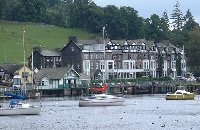
12.05.2010 Day 0: Arrive in Ambleside, Lake District. Possible from Holland to Newcastle on Tyne by ferry then train to Carlisle, change train for Oxenholme then a further short train journey to Windermere then cycle to Ambleside or cycle from Oxenholme to Ambleside. - or travel from Calais / Dover by ferry or 'Le Shuttle' or Lille / St Pancras by Eurostar then train London to Oxenholme and Windermere. Stay at Britain's biggest youth hostel outside of London on the shore of Lake Windermere at Ambleside.
Night (half-pension at Ambleside)
|
13.05.2010 Day 1. The Lake District BIG's 7.30-8.00 : Breakfast/Déjeûner 9.00 : Start with the bike General Programm 90km - 5 BIGs 1st part : 56 km - 3 BIGs km 0 : Windermere -Flat area/zone de plat --> km6 : Ambleside - km11 : BIG 83 Kirkstone Pass - km 16: back to/Retour vers Ambleside - Flat area/zone de plat --> km 25 : Pied/Foot Wrynose - km 28 : BIG 82 Wrynose Pass - Downhill/Descente - km 31 : Pied/Foot Hard Knott - km33 : BIG 81 Hard Knott Pass - Back/Retour Downhill/Descente - km 35 : Pied Wrynose (versant ouest-plus facile: western side , easier) - km 38 : Wrynose Pass - Downhill/Descente to km 41 : Pied/Foot Wrynose - Flat area/zone de plat --> km 50 : Ambleside - km56 Windermere. Alternative tours : 1.1.A : to avoid Kirkstone and to climb Wrynose and Hard Knott : 40km, 2 BIGs 1.1.B : to avoid Wrynose and Hard Knott and to climb Kirkstone : 16km, 1 BIG 13.00 : Break 14.00 : Start with the car Car to Keswick (35km) 15.00 : Start with the bike 2nd part : 34 km - 2 BIGs km 0 : Keswick - Flat area/zone de Plat - km5 : Pied du Honister - km 10 : BIG 80 Honister - Back Downhill/Retour descente - km15 : Pied du Honister - Flat area/zone de plat - km 20 Keswick - km 23 : Pied du Whinlatter - km 27 : BIG 79 Whinlatter - Back downhill/Retour descente - km 31 : Pied Whinlatter - km 34 : Keswick Alternative tours : 1.2.A : to avoid Honister and to climb Whinlatter : 14km, 1 BIG 1.2.B : to avoid Whinlatter and to climb Honister : 20km, 1 BIG 17.00 : Back with the car 18.00 : Youth Hostel 19.00 : Dinner 21.00 : President's speech Night (half-pension at Ambleside) |
|
14.05.2010 Day 2. To Yorkshire's BIGs 7.00-7.30 : Breakfast/Déjeûner 8.00 : Start with the car Car to Penrith (50km) - Millburn (15km) 9.30 : Start with the bike General Programm 114km - 4 BIGs 1st part : 100 km - 3 BIGs km 0 : Millburn - km10 :BIG 76 Great Dun Fell - Back Downhill / Retour Descente - km 20 Millburn - Flat area/zone de plat - km 30 : Melmerby = Pied/foot Hartside Cross - km 39 : BIG 78 Hartside Cross - Downhill/Descente vers/to - km 48 : Alston - Flat area/zone de plat - km 68 Westgate - km 74 : BIG 77 Westernhope Moor - km 80 : Newbiggin - Flat area/zone de plat - km 100 : Millburn Alternative tours : 2.1..A : to avoid Great Dun Fell and to ride the tour with the 2 other ones : 80km, 2 BIGs 2.1..B : to avoid the great tour and to climb simply the Great Dun Fell : 20km, 1 BIG 2.1.C : to climb each big with the bike and to link with the car : 52km, 3 BIGs 2.1..D : to climb Great Dun Fell and to go with the car to Scotland, to climb Lowther Hill and Carter Bar, 3 BIGs (attention, impossible here to reach the 2nd part of the day) 14.30 : Break 15.00 : Start with the car Car to Hawes (50km) 16.30 : Start with the bike 2nd part : 14 km - 1 BIG km 0 : Hawes - km 7 : BIG 84 Fleet Moss - km 14 : Hawes
18.00 : Back with the car to Windermere (60 km) 19.00 : Youth Hostel 20.00 : Dinner 21.00 : Quizz B.I.G Game Night (half-pension at Ambleside) |
|
15.05.2010 Day 3: From Lake district to Peak District 7.30-8.00 : Breakfast/Déjeûner 8.30 : Start with the car Car to Ilkley (100km) 10.30 : Start with the bike General Programm 40km - 2 BIGs 1st part : 40 km - 2 BIGs km 0 : Ilkley - km 2 : BIG 86 Cow & Calf, Downhill to/Descente vers - km 10 Keighley - km 15 : Haworth - km 20 BIG 87 Oxenhope Moor - Back to Haworth, Keighley, km 40 : Ilkley.
Alternative tours : 3.1..A : to avoid Cow & Calf and to climb Oxenhope : 8km, 1 BIG 3.1..B : to avoid Oxenhope and to climb Cow & Calf : 4km, 1 BIG 3.1.C : to climb Cow & Calf (or/and Oxenhope) and to go with the car to Hutton-le-Hole (90km) , to climb Rosedale Abbey 2-3 BIGs (attention, back from Hutton to Castleton with the car 140km) 13.30 : Break 15.00 : Start with the car to Castleton Car to Castleton (90km) 17.00 : Arrival at the YH 19.00 : Dinner 21.00 : Debate about the challenge B.I.G
Night (half-pension at Castleton)
|
|
16.05.2010 Day 4: Peak District's BIG 8.00-8.30 : Breakfast/Déjeûner 9.00 : Start with the bike
General Programm 100km - 3 BIGs 1st part : 90 km - 2 BIGs km 0 : Castleton - Flat area/zone de plat - km 10 : Ashopton - km 20 : Langsett - km 40 : Holmfirth - km 48 BIG 88 Holme Moss - Downhill/Descente - km 60 : Glossop - km 70 : BIG 89 Snake Pass - km 80 : Ashopton - km 90 : Castleton Alternative tours : 4.1..A : to take the car to Holmfirth and to climb Holme Moss : 16km, 1 BIG 4.1..B : to take the car to Glossop and to climb Snake Pass : 20km, 1 BIG 4.1.C : to leave the other members and to climb Welsh or Cornwall's BIGs on our way back, from 3 to 5 BIGs 14.00 : Break 15.00 : Start with the bike 2nd part : 10 km - 1 BIG km 0 : Castleton - km 5 : BIG 90 Mam Tor - km 10 : Castleton Alternative tours : 4.2..A : to ride to Edale (20km) for climbing the steepest side of Mam Tor and go down to Castleton (total 30km) 17.00 : back to YH 19.00 : Dinner 21.00 : Drink to say good-bye Night (half-pension at Castleton) |
Day 6: Homeward bound |
Kevin Speed.
Remarks :
In Ambleside at YHA parking for
30 cars only. Camper vans can use YHA slipway. Call at YHA Reception. Group
is booked as " Challenge BIG" . Ask at Reception to open up slipway
gate and pay £17 per night per vehicle and use of all YHA Ambleside facilities.
If unable to park at the YHA free car park then take a left from hostel and
left at traffic lights and immediately turn right into Ambleside car park. Fee
is £6.50 per vehicle for 12 hours.
Ambleside to Keswick , Honister and Whinlatter passes
Go left out of YHA then at traffic lights go right, continue and follow one-way
system to the left then right and then left again indicated 'Keswick'. Scenic
road but many bends through Rydal and Grasmere - please stop and buy gingerbread
from the shop there - it's famous! After Grasmere Lake the road goes up over
Dunmail Rise then down to Thirlmere. Just before Thirlmere there is a left turn
for a scenic quiet road to the left of the lake but continue on along main road
if time is short. In Keswick follow signs to the left for Borrowdale and continue
along the valley alongside Derwent Water to Seatoller where the 3km steep climb
begins up to Honister Pass. A BIG sticker has been placed on the road sign to
the left next to Honister youth hostel at the summit.
Back to Keswick the same way and take main road A66 for Cockermouth and take
a left indicated for Braithwaite. Park on the right in front of houses. The
very steep climb to Whinlatter Pass begins immediately after passing white buildings
in a narrow section of the road. It is important to take the left turn for Whinlatter
here and not the right turn for Cockermouth as this returns to the A66 road
and is flat.
Ambleside to Great Dun Fell
Take the road to Keswick as described above and just before the town take a
right turn for Threlkeld and Penrith and soon becomes the A66 main road.
Go along here to Penrith and just before the town at a roundabout take the third
turning indicated A66 Brough. Go along here until Kirkby Thore village is reached
then take a left on a narrow road in Kirkby Thore, go to the end of this road
and take a left turn then immediately a right turn indicated 'Knock'. Follow
this road and go round a sharp bend to the right then just past a row of houses
look out for a small brown sign on the left in the grass verge that indicates
'Knock Christian Centre' Take the left turn here and immediately after turning
there is a car park on the right for at least 20 cars. Park then go to Great
Dun Fell. BIG sticker placed on a post 1km from the top on the right as the
road was blocked by snow last month!
Great Dun Fell to Hartside, Westernhope Moor and Fleet Moss
From car park in Knock turn right, go to end of road, take a right and pass
through Millburn, Newbiggin, Skirwith to Melmerby. Good pub for eating on the
right, open all day. Here take a right on the main road where the climb to Hartside
Cross begins. Many motor cyclists on this road - and at the cafe on the top!
BIG sticker placed on the summit marker. Down the other side to Alston. Please
note motorists - there is a petrol station on the left on entering Alston -
there are no more petrol stations between Penrith and St John's Chapel to the
east below Westernhope Moor. The roads A686 and A689 are hilly, especially at
Nenhead to the east of Alston. Alston itself is a very interesting small town
of cobbled steep streets. On reaching Daddry Shield take a right after a row
of stone cottages that has a white railing in front, a glass telephone kiosk
on the corner. The road is indicated 'Brotherlee' Go along here and after a
200 mtres take a right along a narrow lane that soon becomes steep and goes
up to Westernhope Moor. BIG sticker placed on road sign to the left just before
cattle grid at the top. Steeply down other side to Middleton in Teesdale, steep
up again to Brough and hilly road continues for Hawes. Car park in Gayle 0.5
km to south of Hawes, £2.50 for 2 hours. Steeply up after passing over
stone bridge over river, picturesque village of stone houses then the immediate
climb up to Fleet Moss
Fleet Moss to Cow & Calf and Oxenhope Moor
If coming from Ambleside today take A66 from Penrith to Brough then B6259 indicated
Kirkby Stephen and Hawes. From the top of Fleet Moss it is a glorious long descent
through the Yorkshire Dales following the River Wharfe through Wharfedale, Kettlwell
to Threshfield - a good place to meet the cars again if we opt for this recommended
alternative. From Threshfield to Skipton and take right on the roundabout before
the town for A65 Ilkley and Leeds. On entering Ilkley take a right and park
along here for Cow&Calf that begins opposite Ilkley rail station. BIG sticker
at top on left on roadsign. Go over Ilkley Moor and follow signs for Keighley
then to the left for A6033 to Oxenhope. Oxenhope Moor climb begins on Hebden
Bridge Road just past church on the right and just before 30mph road signs is
a turning to the left and immediately steeply up to metal tower, to the left
then continue until Warley Moor reservoir can be seen on the right. The road
becomes a gritted surface and goes on to the windfarm car park. BIG sticker
on the right on a road sign
Oxenhope Moor to Castleton
Go over Oxenhope Moor to Wainstalls - car pick up? And Mount Tabor and into
Halifax. Take A629 indicated Huddersfield, continue on A629 indicated Sheffield.
At edge of the city take A6101 indicated Glossop and merge into the A57 for
Glossop to the west. Continue on to Ladybower Reservoir in Upper Derwent Valley
and take a right at the traffic lights indicated for Bamford and Castleton A6013.
At end of this road take a right at the traffic lights for Hope and Castleton.
In Castleton the hostel is on Castle Road to the left. Car parking is a few
metres further on to the right next to the Tourist Information Office. Parking
is free after 20.00 hours until 08.00. At Castleton YHA the booking is in my
name - quote 'Kevin Speed group'